
GIS Cement Logistics Dispatch System
What Legacy Problems Does a Cement Logistics Dispatch System Solve
A cement logistics dispatch system is a dispatch platform that brings sales and delivery information, in-transit vehicle positions, loading and unloading events, and voice intercom onto a single map. It consists of three parts: a GIS-based command center, a vehicle-mounted IoT audio and video communication terminal, and a carrier APP information terminal. The three ends share one set of vehicle records and task data, and dispatch orders and on-site events flow along the same link. For an enterprise, the value of this solution lies in consolidating scattered logistics information onto a unified platform.
Logistics management in the cement industry is not complicated in itself: arrange the delivery sequence according to sales information, keep track of goods in transit, predict arrival times, reallocate goods reasonably, and avoid potential logistics risks. The difficulty is that these actions used to rely on asking by phone and guessing by experience; once information lags, vehicle detention and material shortages follow.
What the system does is turn these steps into a map that can be viewed, called over, and queried, visually presenting logistics resources and the logistics process to optimize logistics efficiency and reduce costs. Every loading, unloading, delivery, and reassignment leaves a record, so dispatch experience can accumulate into the enterprise's own data.
Three Ends in One: What the Command Center, Vehicle Terminal, and Driver APP Each Handle
The whole system is divided into three ends with non-overlapping responsibilities: the central end watches the overall situation and issues orders, the vehicle end collects and executes, and the mobile phone end handles information operations when the driver is away from the vehicle. All three ends use the same vehicle records and task list, so data does not mismatch across ends.
| Component | Deployment Position | Main Responsibilities |
|---|---|---|
| GIS-based command center | Enterprise dispatch center | Map display of vehicles and construction sites, alarm area definition, private call and group call initiation, mileage, fuel consumption, and task completion statistics |
| Vehicle-mounted IoT audio and video communication terminal | Vehicle cab | Audio intercom, video surveillance, sensor and actuator data communication, AI-recognized event reporting |
| Carrier (driver) APP information terminal | Driver and carrier mobile phones | Event reporting, order receiving, audio intercom, direct calls, signing and handover |
The value of the three ends lies in complementing one another. A mobile phone is a multi-purpose device, and a driver may miss dispatch messages while on a call or taking photos, so critical visual intercom and alarms reside on the vehicle terminal; when the driver leaves the vehicle to load or unload goods and sign for handover, the mobile phone end fills in the events.
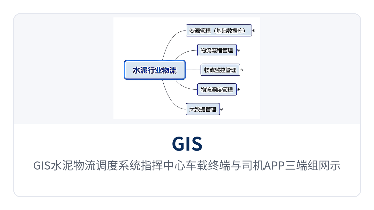
Figure 1: Three-end networking schematic of the GIS cement logistics dispatch system command center, vehicle terminal, and driver APP
How Five Major Stages Manage a Load of Cement from Plant to Site
A load of cement goes through several nodes from plant to site: vehicle assignment, loading, in-transit, unloading, and signing. The five management stages are divided along this chain. Each stage corresponds to a function group in the system, and data flows automatically between stages without manual re-entry.
| Management Stage | Coverage |
|---|---|
| Resource management | Unified records for group customers, carriers, service capabilities, raw material suppliers, and vehicle resources |
| Process management | Process nodes and responsibility division for loading, unloading, delivery, and reassignment |
| Logistics monitoring management | In-transit monitoring of vehicle position, speed, load, and tarpaulin and compartment status |
| Logistics dispatch management | Vehicle assignment, reassignment, and emergency dispatch based on sales orders and vehicle positions |
| Logistics data analysis | Statistics on mileage, volume, fuel consumption, task completion, and alarms, forming monthly reports and assessment basis |
Around these five stages, the system also connects four management lines: business documents, fund settlement, capacity records, and work processes are strung onto the same data chain. The four lines share vehicle numbers and task numbers, so querying one trip reveals the process, costs, and responsibilities together.
- Logistics, fund flow, business flow, and workflow management: business documents and settlement data share the same source, and loading volume, unloading volume, and reconciliation criteria are consistent.
- Group customer management, carrier management, service capability management, and raw material supplier management: external capacity is incorporated into unified records.
- Settlement, accounting, statistics, and reconciliation: automatically aggregated by task and volume, reducing manual reconciliation.
- Loading, unloading, delivery, and reassignment: node status can be reviewed afterwards, and reassignment leaves a trace.
Together, these four lines solve the problem of dispatch and settlement being two separate books. How many trips a vehicle made, how many cubic meters per trip, and how much freight should be settled can all be found in the same data, without the dispatcher and finance each keeping their own books and reconciling at month-end.
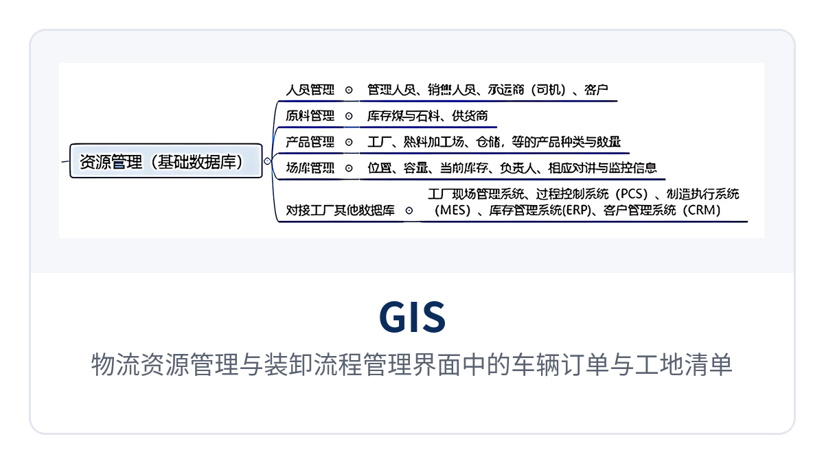
Figure 2: Vehicle orders and construction site list in the logistics resource management and loading/unloading process management interface
What Vehicles and Events Can GIS Custom Layers Mark
Common commercial navigation software offers limited layers, supporting only generic roads and points of interest, not user-defined resource marking and management. In practice, commercial maps are usually converted to a standard geographic coordinate system and loaded onto the GIS platform as a base map.
Custom layers such as grids, paths, and resource points are overlaid on the base map; they can be zoomed in, zoomed out, and panned, and can participate in various distance and range calculations. This is where GIS logistics dispatch differs: what the dispatcher sees is not a public map but the enterprise's own road network, construction sites, and vehicles.
On the layers, annotations can be made for vehicle type, load, speed vector, and task category, so it is clear at a glance which vehicle carries how much, how fast it runs, and what kind of task it performs. Event annotation and monitoring can also be done, such as unloading at a non-destination, incomplete unloading, overtime unloading, and cross-region diversion; once an anomaly appears, it is pinned to a specific vehicle.
Custom GIS layers are defined by the business itself. The plant is divided into grids, transport routes are drawn as paths, and construction sites and mixing plants are marked as resource points; once overlaid, the layers show both a single vehicle and the capacity distribution of an area. The number of layers and annotation rules are maintained by the dispatch department without changing platform programs.
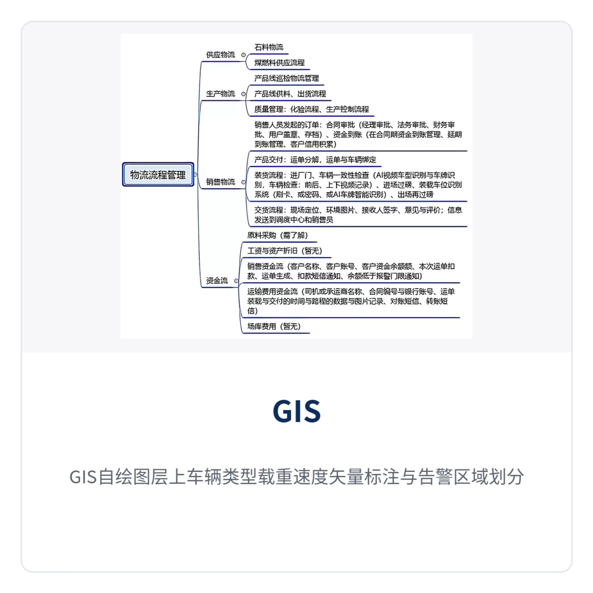
Figure 3: Vehicle type, load, and speed vector annotations and alarm area division on GIS custom layers
What AI Recognition Capabilities Does the Vehicle Terminal Have
The granularity of cement transport vehicle monitoring depends on what is installed on the vehicle. In addition to intercom and positioning, the vehicle-mounted IoT terminal also handles data communication for sensors and actuators, turning physical states such as the compartment, tarpaulin, and electronic seal into signals the platform can judge, so the dispatcher does not have to rely solely on the driver's verbal account of conditions en route.
| Function | Description |
|---|---|
| Audio intercom | Two-way voice calls between the driver and the dispatch center, supporting private call and group call |
| Level-1 alarm and other shortcut operations | Panel shortcut keys report emergency events with one touch, reducing operation steps while driving |
| AI smart camera | Captures cab and compartment images, providing image evidence for anomalies en route |
| Tarpaulin open/close recognition | Determines from images whether the tarpaulin is covered as required |
| Dump compartment sensing recognition | Collects compartment lifting and unloading actions to determine whether unloading has occurred |
| Electronic seal | Electronically controls the compartment seal status to prevent unauthorized opening en route |
| Concrete mixer truck forward/reverse monitoring | Monitors mixer drum rotation; reverse rotation means discharging, used to determine unauthorized unloading |
| RFID packaged delivery scanning | Scans tags at packaged cement delivery to complete handover confirmation |
These recognition items target several common anomalies in cement and concrete transport: tarpaulin opened en route, unauthorized unloading, seal tampering, and irregular mixer drum rotation. AI tarpaulin recognition combined with the electronic seal turns whether the cargo has been tampered with from a verbal inquiry into an event with images and records.
Both vehicle-mounted mobile phone APPs and dedicated devices can implement cab video surveillance, PTT intercom, and BDS/GPS track upload. Raytrans's IDM-MCC dispatch system networks along this path, providing reusable vehicle-mounted IoT terminal networking experience for scenarios such as smart mining communication solutions. Which type of terminal to choose depends on whether the vehicle needs intercom always on, whether video backhaul is required, and whether compartment sensors need to be connected. As a command and dispatch system manufacturer, Raytrans's accumulation in logistics dispatch systems and enterprise communication solutions is reflected precisely in the flexibility of such terminal selection and networking.
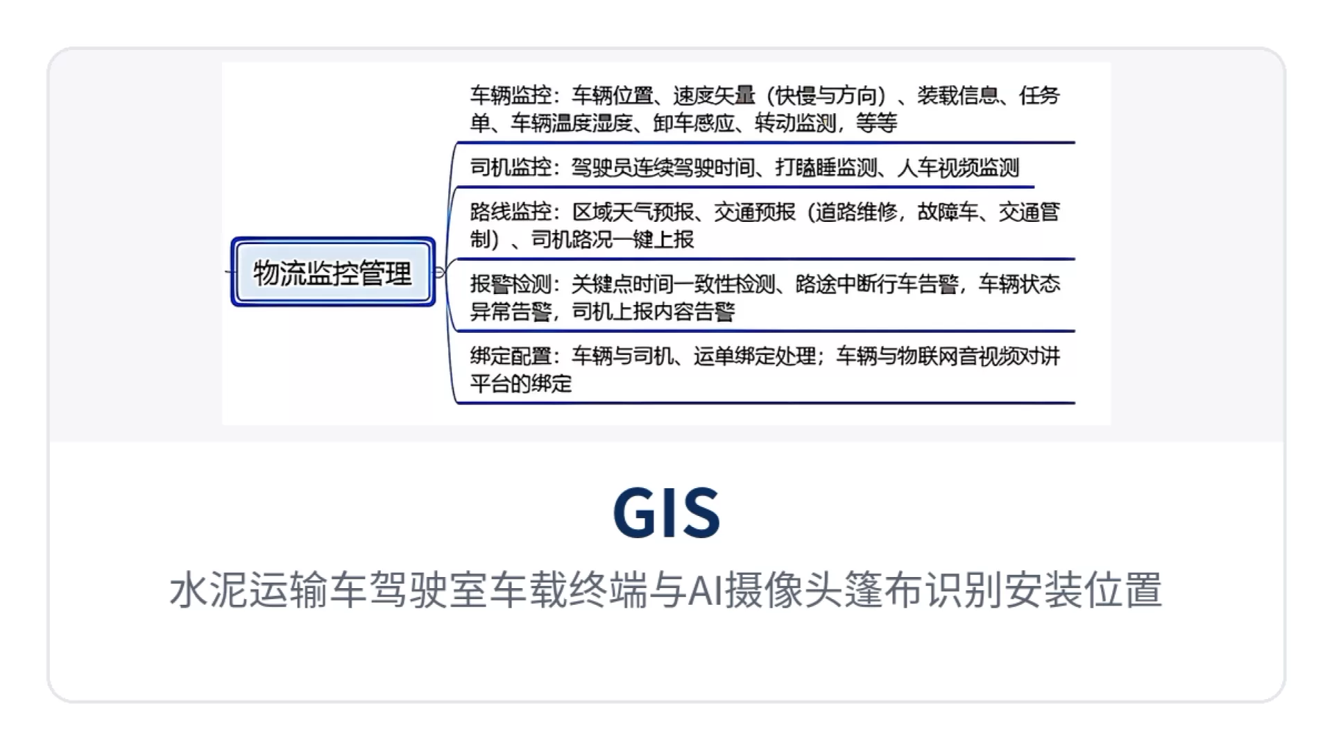
Figure 4: Installation positions of the vehicle terminal and AI camera tarpaulin recognition in a cement transport truck cab
How 4G Intercom Achieves Instant Response
4G intercom group call is a key capability of this enterprise solution for on-site response speed. Intercom runs over the 4G network with a suitable data plan, independent of the relay coverage of existing analog intercom, so vehicles remain in the same intercom network after leaving the plant and reaching remote construction sites.
| Intercom Capability | Description |
|---|---|
| Group call | Fast one-to-one and one-to-many calls, automatic group formation without dialing, talk on connection, instant monitoring |
| Private call | One-to-one call between the dispatcher and a specific vehicle |
| Group call | One order delivered simultaneously to multiple vehicles in a fleet |
| Group management | Supports multi-group management and temporary group management, with temporary grouping by construction site or task |
| Multi-group online | One terminal can be defined in several different groups; the system automatically scans whether the terminal is busy and, if not busy, can receive calls from different groups |
| Presence display | The terminal shows the online, offline, group call, and private call status of users in the same group |
| Voice recording | Records the content of each call, queryable and playable back as needed |
| Dispatch function | Backend GPS satellite monitoring and dispatch, determining real-time positions of vehicles and personnel, real-time voice dispatching, automatic vehicle selection, and conference calls |
The action most used on site is calling a specific vehicle directly. When the dispatcher sees vehicles queuing at a construction site on the dispatch interface, one click on group call lets several vehicles hear the reassignment order at the same time without dialing each one; call content is recorded, so disputes can be reviewed afterwards by playback, and the day's dispatch rhythm can be reviewed. This visual intercom capability makes dispatch orders more intuitive and reliable to issue.
The multi-group online rule is worth explaining: when a vehicle belongs to both a fleet group and a temporary construction site group, the system first checks whether the terminal is busy and only connects a new group call when it is idle. Thus the dispatcher does not need to know whom the driver is currently talking to, and emergency orders are not lost due to a busy line.
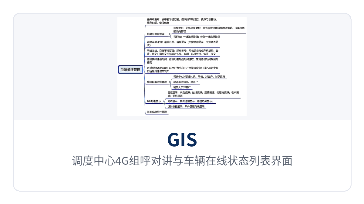
Figure 5: 4G group call intercom and vehicle presence list interface in the dispatch center
How to Set the Four Types of Alarms and How Positioning Data Is Backhauled
The dispatch center can define alarm areas on the GIS; when a vehicle enters or leaves the area, the system sends an alarm message. The plant, construction sites, and restricted road sections can each be set as separate areas; area speeding alarms are judged jointly by area rules and speed thresholds, and are triggered only when the vehicle speeds within the area.
| Alarm Type | Trigger Condition | On-site Use |
|---|---|---|
| Area monitoring alarm | Vehicle enters or leaves a defined alarm area | Determine whether it deviates from the specified route or arrives at the construction site |
| Speeding alarm | Vehicle speed exceeds the set limit | Constrain speeding, reducing fuel consumption and accident risk |
| Overtime alarm | Vehicle stops longer than the set time limit | Detect prolonged detention and roadside parking |
| Transport overtime alarm | Vehicle transport process exceeds the set time limit | Warn of delays in advance to avoid material shortages at construction sites |
Vehicles send position, speed, and other data to the dispatch center in two working modes: first, active sending at fixed intervals and fixed length, with the interval set by the dispatch center; second, query mode, where current status data is sent only after a query order is received. The two modes can coexist on the same batch of vehicles. In this step, the vehicle-mounted IoT terminal is responsible for collecting and backhauling position and status data.
The two modes suit different scenarios: active reporting for daily monitoring ensures continuous tracks; query mode is used when data traffic cost is a concern or only specific vehicles are queried, reducing idle reporting. How long the reporting interval should be depends on vehicle density and the number of construction sites; too dense an interval increases traffic and storage pressure.
What Drivers and Carriers Do on Mobile Phones
After the carrier and the driver leave the vehicle, they can use the IOT365 APP for information operations, enabling event reporting, audio intercom, direct calls and order acceptance. Positioning and intercom remain primarily the responsibility of the vehicle-mounted terminal; the mobile phone fills the gap when no one is in the cab.
The IOT365 APP provides a WeChat-like operating interface, but adds timely broadcast, IoT terminal management, portable dispatch console switching and back-end big data acquisition. The IoT terminals it can manage include vehicle-mounted terminals, elevator intercom and access control intercom; with support from the central end, it can also intercom with WeChat groups.
What can be done in the APP falls into two categories: events that occur on the road, and calls between the driver and the dispatch center. Both types of records are attached to the same transport task, so a review afterwards shows who reported what and when, and how the dispatcher replied at the time.
- Event management: loading and unloading events, loading and unloading volumes, loading and unloading location events, signing and handover.
- Intercom management: audio intercom, video surveillance, IoT data acquisition.
Ready-mixed concrete truck dispatching depends even more visibly on the mobile phone. After arriving at the site, the driver must report arrival and report completion of unloading, and photograph the signed receipt for backhaul; all these actions are completed in the APP, and the dispatcher at the central end sees the site status in real time without calling again to confirm how many trucks are still waiting at the site.
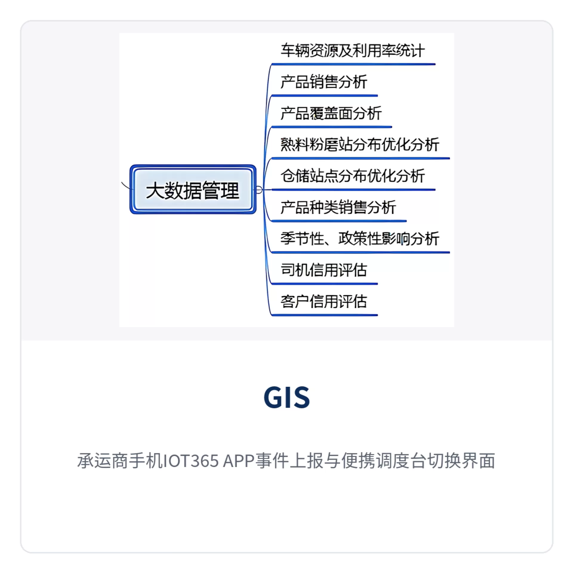
Figure 6: Carrier mobile IOT365 APP event reporting and portable dispatch console switching interface
How the dispatch center reduces truck queuing and material shortages
How to reduce queuing at sites
The root cause of queuing is that dispatch does not know how many trucks are still waiting at the site. The dispatch interface visually displays the vehicle usage of each site and the operating status of each vehicle, so the dispatcher can arrange production in good time and dispatch vehicles reasonably, allocating capacity to the sites that need it more urgently; long queues at site gates are thereby reduced.
How to detect material shortages at sites in advance
Shortages often occur during shipping peaks. The system dynamically shows the number of vehicles that have arrived at each site and the road distance of vehicles from the site; sites that are far away and have few vehicles on hand are replenished in advance, avoiding quality problems and customer complaints caused by prolonged shortages, and reducing passive explanations at the service level.
How to reroute for emergency dispatching
When traffic jams or road closures occur, material originally planned for site A may be affected in quality due to time. The driver can report an emergency to the dispatch center by vehicle-mounted voice, and the dispatcher changes the transport route or delivery destination on the map on the fly, issuing the instruction through a single group call instead of calling each truck one by one.
How to eliminate navigation blind spots
More than a dozen new sites are taken on every month, and drivers are unfamiliar with the routes; asking for directions for over ten minutes is common. Dispatch does not know the specific locations of drivers and sites and cannot give correct navigation; wrong turns waste time and fuel, and calling while driving also affects safety. Marking site locations into layers gives navigation and vehicle dispatching a common coordinate system.
How to manage fuel consumption and driver behavior
The system automatically collects statistics on each vehicle's mileage, monthly delivered volume and fuel consumption, and can calculate fuel consumption per cubic meter per kilometer, making vehicles comparable and enabling rewards and penalties. Speeding alarms and track playback leave traces of fuel theft, material theft, idling and deliberate rerouting, giving fleet management a verifiable basis.
Which enterprises should adopt this system first
Logistics dispatch departments of cement clinker bases and grinding stations
Such enterprises have large shipping volumes and scattered sites, and sales orders and departure plans need to be aligned daily. By putting shipping sequence, vehicles in transit and site inventory on the same map, the logistics dispatch system can bring capacity into place before and after peaks, reducing idle waiting both in plant queues and at sites waiting for material.
Ready-mixed concrete enterprises and carrier fleets
Ready-mixed concrete is time-sensitive, and drum forward/reverse rotation, unloading locations and arrival times must all be recorded. Forward/reverse rotation monitoring and AI recognition on the vehicle-mounted terminal, together with loading and unloading event reporting in the APP, enable carriers to provide clients with verifiable transport process records and a unified basis for settlement.
Industrial private networks of group cement enterprises
A group operates multiple grinding stations and fleets, and data standards differ from point to point. The GIS platform builds layers by area, the command center views the whole picture in a unified way, each site views local data according to permissions, and the group level compares capacity and costs without waiting for monthly reports from each plant to be aggregated.
Step-by-step implementation sequence
Implementation usually proceeds in five steps, each corresponding to a visible change on site. First make vehicles visible, then make instructions audible, and finally make data accountable. Each step has acceptance-ready outputs; after completing one step, part of the on-site change is visible, without waiting for the entire system to go live before evaluating results.
- Sort out the shipping process and site list, and define the loading point, unloading point and time limits for each route.
- Convert commercial maps into standard coordinate base maps, and overlay self-drawn layers such as grids, paths and resource points.
- Connect the vehicle-mounted terminal to intercom, video and sensor signals, and install the IOT365 APP on the driver side and bind it to the vehicle.
- Configure alarm areas, speed thresholds and group call groups, and solidify commonly used dispatch instructions into rules.
- Use mileage, volume, fuel consumption and alarm data for monthly assessment, then adjust routes and capacity based on the results.
The five steps depend on one another in sequence: if the base map and vehicle records are not clarified, alarm areas cannot be drawn accurately; if group call groups are not organized by site, temporary reassignment still relies on phone calls. The project cycle depends on the number of vehicles and sites; it is recommended to run a trial on one production line or in one area first. As a command and dispatch system manufacturer, Raytrans can provide overall solutions ranging from smart mining communication solutions to logistics dispatch systems, helping enterprises advance through each implementation stage in an orderly manner.
Conclusion
The value of a cement logistics dispatch system lies not in the software interface, but in aligning the three time segments of shipping, transit and unloading. GIS self-drawn layers make vehicles and sites visible on the same map, visualized dispatching group calls deliver instructions in one go, and AI recognition and alarms on vehicle-mounted IoT terminals keep anomalies in the records.
For cement and ready-mixed concrete enterprises, starting with one area and one production line, calibrating alarm thresholds and vehicle dispatching rules with real data, and then rolling out to group sites makes results easier to see than a one-time full-scale deployment. As a command and dispatch system manufacturer, Raytrans's accumulated solution experience in smart mining communication solutions and logistics dispatch systems shows that transport is a compressible part of cement costs; once dispatch efficiency rises, profit margin follows.