Land and Resources Administration Information Management System
Based on the actual work of land and resources management in China, Raytrans has launched a command…
1. Overview
The world today has entered the information age. Information technology is powerfully and profoundly driving profound changes in all fields of economy and society, becoming the most potentially productive force of the contemporary era. Information resources have become strategic resources for national economic and social development, and the level of informatization has become an important indicator of the modernization level of a region or city. As a major component of social informatization, land and resources informatization is of great significance for innovating land and resources management methods and operating mechanisms, clarifying the tasks of land and resources informatization construction, carrying out land and resources informatization work in a planned, step-by-step and prioritized manner, and supervising and inspecting land administrative law enforcement and the implementation of land and mineral resources planning. Realizing a network-based comprehensive management system of "monitoring from the sky, inspecting on the ground, and managing online" is a very important and urgent task.
2. Function Introduction
Based on the actual work of land and resources management in China, Raytrans has launched a command, monitoring and dispatch system for the land and resources industry. It features immersion, interactivity and imagination, enabling users to be immersed in a virtual environment for interactive operations. It provides powerful functions for digitization, networking and optimized decision-making of complex urban systems including urban geography, resources, ecological environment, population, economy and society, and is used for effect rehearsal of major decisions and prediction of future development. This technical strategy of using information technology for urban management is a new approach that combines high-tech with traditional industries and continuously innovates traditional urban construction and management methods, and is of great significance in modern urban construction and management. It builds a software platform integrating 2D GIS data and 3D scene data to achieve unified management of massive city-level 3D digital model data and the application of high-precision models. In the field of urban construction and management, it carries out research on management models based on 3D digital technology, applies 3D digital technology comprehensively to urban visual management, and further improves the informatization level of urban management.
2.1 Display Design: Comprehensive and three-dimensional display functions with rich display methods
Advanced visualization technology is applied in data and information display, effectively combining remote sensing technology and geographic information technology to achieve three-dimensional, real-time and intuitive display effects.
The 3D geographic information management system has powerful functions for digitizing, virtual simulation, optimized decision support and visual representation of complex urban systems including geography, resources, environment, population, economy and society. It gradually establishes and improves a unified sharing platform for urban 3D basic data.
3D geographic information technology is used for the management of urban components, truly reflecting the accurate location and related information of each urban component, and enabling analysis and management of the queried information. For example, for location and information queries of manhole covers and billboards among urban components, the position and information of each manhole cover or billboard can be seen at a glance, including where manhole covers are missing and where illegal billboards exist, allowing managers to conduct visual analysis and management.
3D Function Display:
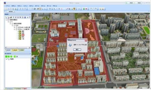
- The total area of a plot or a region can be measured, more commonly used for planning and real estate development projects.
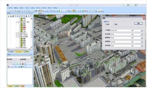
- Measure the distance between two or several buildings to obtain the interval value between the building group, and the distance line can be extended indefinitely.
2.2 Real-time Dispatch of Patrol Vehicles by the Command (Monitoring) Center
According to work requirements, command center staff dispatch field patrol vehicles in real time to conduct on-site inspections of suspected illegal map spots reported by three-level network patrol personnel, and transmit the on-site inspection results back immediately.
The command, monitoring and dispatch center can provide the following two methods for vehicle dispatch:
Method 1: Dispatch the nearest vehicle to the site.
With this method, the law enforcement vehicle-mounted terminal downloads the city's basic data via GPRS/CDMA and other wireless communication methods. The command, monitoring and dispatch center automatically determines the nearest vehicle to dispatch based on vehicle location and map spot location, generates a task list, and after the law enforcement vehicle receives the task on the terminal, it conducts on-site inspection and performs scene scanning through the scanner, then returns the results to the command, monitoring and dispatch center wirelessly.
Method 2: Dispatch the responsible vehicle for the designated area to the site.
With this method, the law enforcement vehicle-mounted terminal computer only needs to download the basic data of its own responsible area, which also facilitates assessment. The command, monitoring and dispatch center sends map spot data based on the pre-determined vehicle responsibility areas and map spot locations, generates a task list, and waits for vehicle feedback.
2.3 Flexible Networking
Based on the hardware and network conditions of the command, monitoring and dispatch center, a data server is established on the intranet to store current and historical patrol land information and patrol information sent back by external patrol vehicles; a command, monitoring and dispatch system is established on the extranet, which can access external networks through multiple communication methods, receives instructions transmitted from the intranet server, and forwards them to external patrol vehicles; external patrol vehicles reply with information through vehicle-mounted terminals, send it to the communication server, and then transmit it to the intranet server. GPRS or CDMA wireless data communication is adopted between the command, monitoring and dispatch system and the vehicle-mounted terminals of patrol vehicles. The terminal equipment of external patrol vehicles is equipped with a multifunctional operation screen to realize functions such as data reception, display, filling and upload.
2.4 Monitoring of Projects Under Construction
To better judge the future supply situation of the real estate market, the command, monitoring and dispatch center can establish a monitoring system for all approved-but-unbuilt plots and residential projects under construction in the city.
Through indoor data interpretation of project land supply conditions, combined with monthly on-site inspections by field personnel, it determines whether each approved residential plot in the city has started construction and the changes in project progress of each residential project under construction. It updates the GIS database in real time, conducts full-process monitoring of the long-term, medium-term and short-term supply of the local real estate market, provides forward-looking indicator data for macro-control, and assists decision-making.
2.5 Wired and Wireless Communication System
The 800 MHz digital trunking government common network is a professional wireless dispatch system and command communication network provided for emergency response to sudden public incidents, emergency linkage, daily management and social services. Through our wired and wireless dispatch system, communication between mobile phones (fixed-line telephones) and digital trunking terminals can be realized.
Communication between the command, monitoring and dispatch center and daily patrol vehicles and law enforcement vehicles can adopt 800 MHz digital group calling or directly call vehicle-mounted terminals through the dispatch console. When the command center detects a situation, it dispatches relevant patrol personnel or law enforcement personnel to the site in real time through wireless intercom.
2.6 Application Level
The system unifies the information base plate based on land-building-house, fully integrates planning management content, and extends the industry's dynamic information supervision process to the planning level. This enables the entire information base plate to not only provide real-time viewing of current information and trace historical data in the future, but also have the function of foreseeing planning changes for a certain period in the future. The command and monitoring functions of the entire command center cover all businesses from planning to land and resources management in the whole process, further improving the industry management level and enhancing comprehensive social service and support capabilities. The 3D GIS system will establish a full-process planning and land and resources management element database by centrally collecting various planning and land use data of underground, surface, above-ground buildings and structures, thereby building a unified city-wide planning and land and resources management platform. It realizes standardized, multi-dimensional and multi-level data centralization, forming a coordinated, interconnected networked integrated office platform. It builds a city-wide "one map" as an important basis for management, providing detailed data support for administrative approval, law enforcement supervision, emergency supervision and decision support.


Land and Resources Administration Information Management System,Land and Resources Administration Management System,Land Bureau Information Management System,Land Bureau Management System,Land and Resources Administration System
FAQs
What Is the Definition of Communication?
Communication: the exchange and transmission of information between people, or between people and nature…
View answerWhat is the difference between optical fiber and optical cable? What are the common optical fiber connectors?
Optical fiber is a medium that transmits information from one end to another. It is a glass or plastic fiber that…
View answerWhat is the difference between single-fiber and dual-fiber?
The biggest difference between single-fiber and dual-fiber optical terminals lies in the optical modules on their…
View answerWhat is E1? How to Use E1
What is E1 The European 30-channel pulse code modulation PCM is abbreviated as E1, with a rate of 2.048Mbit/s.
View answerPCM30 Working Principle: What Is PCM30/32
PCM30 Equipment Working Principle The 30-channel PCM equipment refers to equipment that provides 30 user interfaces and…
View answer